Gå til innhold

New Simrad® App Launches Loaded with Navigation Features & Support for Simrad® Displays


Egersund, Norway – The latest Simrad® App debuted this week for the marine electronics leader celebrating its 75th anniversary this year. The updated app includes a premium offering complete with new mapping features, advanced functionality and mirroring and control of Simrad® multi-functional displays from your smartphone or tablet. It is available on both the Apple Store for iOS and Google Play for Android.

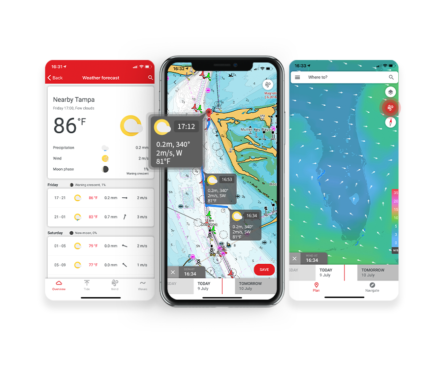
The app is free to download and offers a rich experience that includes free up-to-date nautical charts from C-MAP®, personal waypoints, routes and tracks, latest marine weather, personalization and much more. The app also allows you to register your Simrad® device(s) ensuring you have the latest software, manuals, information and product tips, as well as the ability to synchronize your waypoints and routes. The premium version has additional functionalities including stand-alone navigation.


“The new mirroring feature allows you to view and direct your Simrad electronics from anywhere on the boat right from the palm of your hand,” said James Methven, Global Head of Brand, Simrad Yachting. “This easy integration with companion devices along with intuitive C-MAP charts and features make the Simrad® app a no-brainer for any Simrad® user to download and use.”


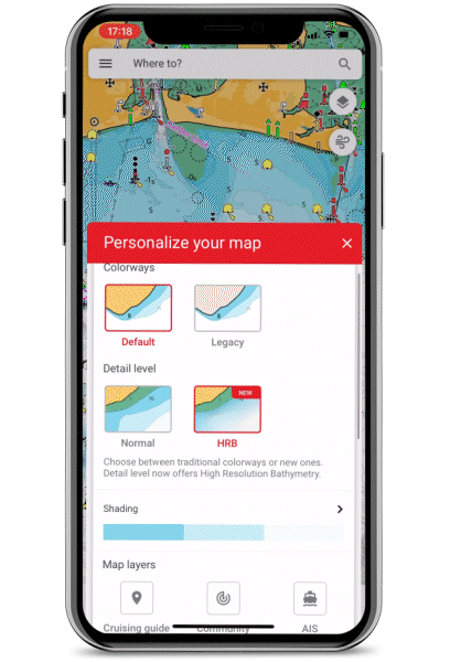
The premium version of the Simrad® App offers Global charts and offline maps, High-Resolution Bathymetry Charts, Automatic Identification System (AIS), Simrad® Community Traffic, 5-day weather overlay along route and 5-day weather overlay, GPS navigation data and line, track recording plus custom depth shading. The full complement of weather data is provided in both versions including wind data, sea state, tides and currents, water temperature and much more. The Simrad® App also features detailed fishing information for anglers and sport fishing enthusiasts.

“The simplified ‘freemium’ option provides a long list of technology and functionality right to your smartphone or tablet at no cost to enable your fishing, yachting and powerboating experience near shore or offshore,” added Methven. “Plus, now we provide the option for an easy annual subscription upgrade to receive crucial premium features like offline charting and enhanced GPS data, custom depth shading and our new weather overlay for 5-days along your route.”


The C-MAP charts on the app are carefully designed to highlight what is most important at any given time during your boating experience, maintaining accuracy and a clean, uncluttered view. Charts are powered by data from official hydrographic offices and continuously updated and augmented from thousands of data sources to enrich data near shore or offshore to provide clarity for your routing, whether that’s a short trip across the bay or longer voyage on the open water.

GRATIS
Oppdaterte sjøkart
Personlige veipunkter, ruter og spor  
Manuell ruting og Autorouting  
Avstandsmålingsverktøy 
Tusenvis av severdigheter 
Maritime værvarsler  
Vær langs ruten i 24 timer
Væroverlegg i 24 timer 
GPX-import og -eksport 
Karttilpassing: båtstørrelse, måleenheter, karttype, visningsmodus (automatisk, lys eller mørk) med mer
Enhetsregistrering 
Enhetsstøtte: håndbøker, veiledninger og videoer 
Speiling og styring 
Offline-synkronisering av vær, ruter og spor
Tilpassede varsler (kategorivise)
Deling av spor


PREMIE

Offline-kart (globale sjøkart)
AIS 
5-dagers vær langs ruten   
Navigasjon: GPS-data, navigasjonslinje, sporhistorikk 
Traffic: hold et øye med andre appbrukere rundt deg 
5-dagers væroverlegg 
Høyoppløselig batymetri
Tilpasset dybdesjattering 
Skyggelagt lettelse
Satellittoverleggsvisning
NYTT: Ankring med varsler


GRATIS
Oppdaterte sjøkart
Personlige veipunkter, ruter og spor  
Manuell ruting og Autorouting  
Avstandsmålingsverktøy 
Tusenvis av severdigheter 
Maritime værvarsler  
Vær langs ruten i 24 timer
Væroverlegg i 24 timer 
GPX-import og -eksport 
Karttilpassing: båtstørrelse, måleenheter, karttype, visningsmodus (automatisk, lys eller mørk) med mer
Enhetsregistrering 
Enhetsstøtte: håndbøker, veiledninger og videoer 
Speiling og styring 
Offline-synkronisering av vær, ruter og spor
Tilpassede varsler (kategorivise)
Deling av spor


PREMIE

Offline-kart (globale sjøkart)
AIS 
5-dagers vær langs ruten   
Navigasjon: GPS-data, navigasjonslinje, sporhistorikk 
Traffic: hold et øye med andre appbrukere rundt deg 
5-dagers væroverlegg 
Høyoppløselig batymetri
Tilpasset dybdesjattering 
Satellittoverleggsvisning
NYTT: Ankring med varsler


For more information on Simrad® and its celebration of 75 years of innovation this year, visit the World of Simrad.