
Boat app picks for easier boating
Boat app picks for easier boating
Smartphones and tablets have added a whole new dimension to the boating experience. They allow you to stay in touch, which for many in this busy age probably enables you to get away for longer. Games, video and music all help to keep the crew happy when on passage or perhaps when sitting out a bit of inclement weather.
Mobile Apple and Android devices also have a growing range of boating apps that are geared to enhance your enjoyment, performance and safety on the water. They put information in your pocket where it is easy to reference and provide very useful secondary data for navigation and weather when in range of a signal too.
The iOS and Google Play stores have a plethora of titles on offer, so we thought it would be good to pick out nine apps that are recommended to add something to your boating experience afloat and fire your imagination ashore.
Simrad App
The Simrad® App can be used as a standalone tool or synced with Simrad® devices for added benefits.
Key features of the free version include:
- Free up-to-date C-MAP® charts when you have phone data
- Personal waypoints, routes and tracks
- Chart personalisation
- Manual and Autorouting planning
- Marine weather forecasts
- Weather along the route for 24 hours
- Thousands of Points of Interest
- Device registration, support, mirroring and control
- GPX format data import and export
- Measuring distance tool
The subscription option adds:
- Offline C-MAP® charts for anywhere in the world
- AIS and also detection of other Simrad App users
- Five-day weather along the route and overlay
- Navigation functions including GPS data, navigation line, track record
- High-resolution ocean floor images
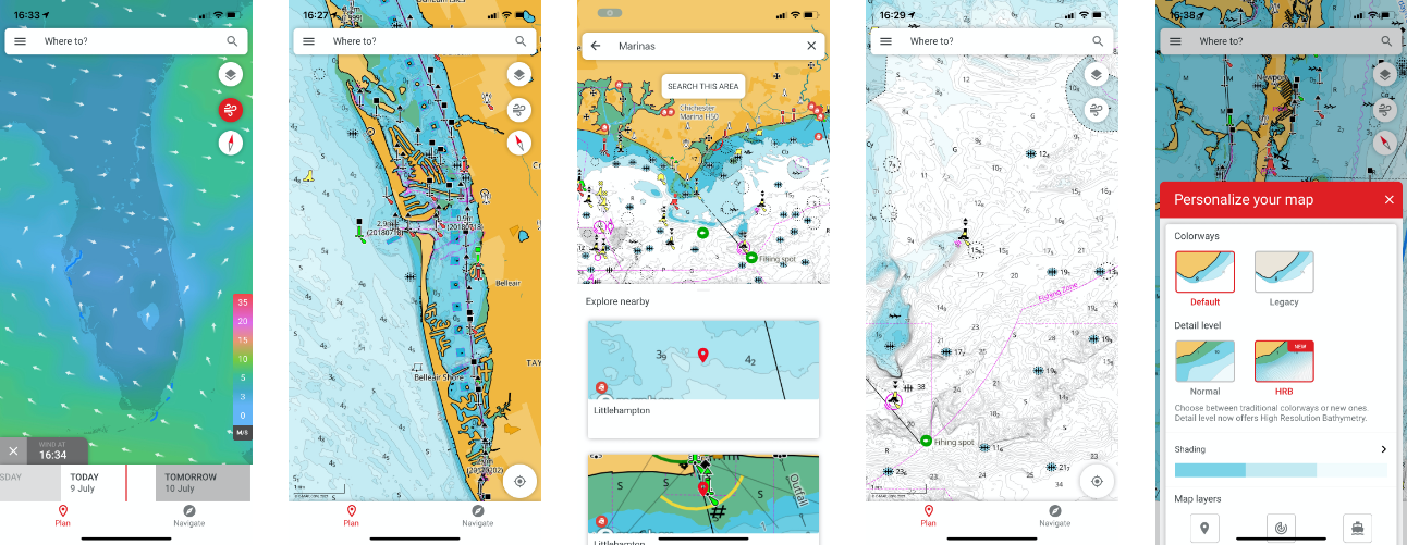
Whether used ashore or afloat, this app is an invaluable pocket chart plotter that assists immediate planning and inspires future adventures. We use it all the time here on the World of Simrad® when cross checking facts. You can integrate it with compatible Simrad® chartplotters and it’s also a great thing to have in your pocket to use as a secondary check if using a borrowed or chartered boat.
The Simrad® App is compatible with both Apple iOS and Android devices and can be downloaded from Apple App Store or Google Play Store – updates and additional features are being added regularly.
Knots 3D
Whether to ensure that your boat is secured correctly, or keeping the crew entertained, a little knowledge of knots goes a long way. Some people master and remember knots easily, others struggle but either way the Knots 3D app is a great way of learning and remembering them.
This app allows you to view the knot-tying process in three dimensions, which is a lot easier than looking at a static book page. You can use the app to improve your existing skills as well, and it’ll make you look like an expert while tying up at the dock, or when weaving a decorative knot with the dexterity of a magician.
Knots 3D is available for a fee on both iOS and Android phones and tablets.
AyeTides
Time and tide wait for no man, as the saying goes. Boating in tidal waters is always governed by the amount of depth available, whether trying to access a haven across a shallow bar, or wanting to know the direction and strength of tidal streams to aid progress or avoid nasty wind against tide conditions.
Tidal data is now getting built into many navigation programs like the Simrad® App, but sometimes it’s nice just to have a specific quick at-a-glance reference to tidal height, time and stream, anywhere you happen to be or wish to travel to. That’s where the AyeTides app excels. This program has built a good reputation over several years and supports worldwide tides and US current station data in more than 12,000 locations. Information is offered in graphical and tabular form. Once you locate your chosen tidal station, simply scroll across chosen days and times to see the estimated height and stream.
AyeTides is available for a fee from the Apple App store and is available in three varieties – standard for mobile, XL for iPads and Mac for laptops and desktops.
Dockwa and Navily
We’re mentioning two entirely separate apps here as both help with your choosing and booking boating destinations.
Dockwa is focused on the US and enables you to reserve slips or moorings at marinas, yacht clubs, and boatyards right from your phone. It lists hundreds of marinas and yacht clubs all over the country and is available as a free Android or iOS download.
Navily focuses on European waters and draws on the experiences of its 300,000 worldwide users to not only rate and recommend more than 700 partner marinas in the region, which you can book and communicate with, but also anchorages and other havens. In effect it works as an always updating cruising guide and the Premium paid-for service removes ads, improves information filtering and enables offline viewing. Navily is available for Android and iOS.
GetMyBoat
There are a number of new platforms offering an Airbnb-like service for boat rental. Among the leading examples is GetMyBoat, which has more than 140,000 powered and sailing craft of all sizes available across the world. Using the platform you can find boat rentals, charters, small watercraft, tours, lessons and adventures on coastal waters and waterways.
This app also enables boat owners to rent out their equipment or experience to other people looking to enjoy some time out on the water. Boat rentals are usually arranged by the hour and can include a captain if required. Get My Boat is available for free on Android and IOS.
Marinus ColRegs Lite
Whatever technology you surround yourself with, for boating at sea you cannot escape the need to learn the 'International Regulations for Preventing Collisions at Sea', otherwise known as the IRPCS or ColRegs. These form the essential rules of the road for everyone to follow.
Marinus ColRegs Lite is an iOS and Android app that helps you learn and reference these rules via graphical displays and it’s a free download too. The App includes quizzes to help you learn and also the full text of the IRPCS, which is a bit of a dry read but very useful for full understanding of your legal obligations.
MarineTraffic
MarineTraffic tracks the real-time locations of all AIS-equipped boats and vessels on a chart on your phone. Using a large network of land-based AIS receivers, the app covers most major ports and shipping routes. AIS is a boat locator transmitter required on commercial vessels, and voluntary on private boats.
What makes this app even cooler is that it lets you click on a boat on the map, which opens a page of detailed information and photos of the freighter or cruise ship. You can learn where the vessel is headed, its current speed, and direction. So it’s useful when in range of a mobile signal afloat but also great fun to use when ashore. The App works on iOS and Android and the free version should be good enough for most amateur boaters, although if you get hooked subscriptions are available that offer more functionality.
Nebo
Nebo is an easy-to-use boat logging app that makes it easy to record and share your boating experiences. Its automated voyage logging function can record detailed boat logs including weather observations and photos, while generating a daily boat log emailed to your account, making it easy to share voyage details and updates with family and friends. Monthly tracking records can also help keep track of maintenance items and monitor operating costs.
An optional Nebolink unit also enables automatic logging each time your boat moves, but the basic app works fine standalone if you simply want somewhere to keep your log and reference it wherever you are. Get the app free on Apple or Google Play.


